One waypoint, and it gets there.
Point and click. It takes what the unit already has, the satellite image, the MCOO, the map, and plans its own way. It drives by sight, through dust, smoke, fog and tall grass, with or without GPS, deals with whatever is in the way, and does it at night with nothing emitting. Mission command for a machine: you give it the objective, it works out the how, and the job gets done.
Risk to equipment, not risk to force.
A course it had never seen
Obstacles added that morning, tall grass after rain, standing water. Nobody drove it by hand.
Watch the runs ↓Night, on a thermal camera, lights off
Two courses in the dark on a single thermal camera. No lidar, no illumination, nothing emitted.
Watch the night run ↓On Army ground, with Army engineers
The Army's ground vehicle engineers' own course at DEVCOM GVSC, under a cooperative agreement.
Watch the Arsenal runs ↓The route gets driven first, by something you can afford to lose
Squad and platoon leaders: eyes forward without a soldier forward.
The next rise, the route ahead of the breach, the last tactical mile of a resupply. Each is a soldier exposed today, or a teleoperated robot with a soldier in radio range. Send this one instead, day or night. If it does not come back, the unit has lost a robot.
The operator: run several, drive none.
One waypoint, not a route. No path to plan around obstacles, no controller in hand. If the vehicle has a radio you have eyes on it and an override; the robot does not need the link to move.
The commander: buy them in numbers, lose some, keep going.
Nothing in the kit emits: nothing to deconflict with the EW plan, nothing in the kit to attack. It does not need GPS to see, plan or avoid. It knows dust and smoke from a wall, where a lidar stops at both. No lidar to sustain. When it gets something wrong on your ground, your own data fixes it in a controlled release the same week.
The scout that maps for the vehicles behind it.
It builds its own MCOO for the chassis it is on, from whatever imagery the unit has, before it moves, and corrects it as it drives. A rut that stops the small robot is a go for the side-by-side behind it: same eyes, same brain, a different vehicle profile. Pushing the corrected map back over the vehicle's radio, so the first run plans the second, is next.next
Mission command for a machine
You give it the objective. It plans from what the unit already has and drives by what it sees. Where a step is still in integration, it says so.
Before it moves: its own MCOO.
An MCOO is vehicle-specific: go, slow-go and no-go for one mobility class. Terra AI builds one for the chassis it is on from the satellite image, the map or the unit's own overlay, then plans a path through it.
On the move: it sees the ground, not a map of it.
Learned traversability from cameras judges positive and negative obstacles, tall grass, washouts, water and moving obstacles the way a driver does, and bends the path around them without a re-plan from anyone.
People: it stops.
Detects people and stops for them. One bounded learned layer sits inside deterministic control code an engineer can read, so the safety case is argued once and holds across model updates.
GPS-denied by design.
It does not need GPS to see, plan or avoid; it drives by sight. A fix is a convenience for naming the waypoint, and when the fix drops it keeps going. Eight seasons under tree canopy, where there is no fix, are why. Legs that start with no fix at all are being integrated now.
Dust, smoke, fog: it knows a cloud from a wall.
A lidar returns a point from dust the same as from a wall, and has to stop at both. A camera-first model classifies what it sees, so it drives through what is passable and slows for what is not. Thermal in the kit sees through smoke and dust where the eye cannot. It is the stack built for the ground where the air is not clear either.
Night: a thermal camera, no lights.
The same model drives from an uncooled thermal camera with nothing illuminated and nothing emitted. Walking pace today; a fused day-night model and daytime speed are on the 2027 schedule.speed in integration
Mistakes: fixed in a controlled release.
The vehicle labels its own data by what it drove. Data from the unit, retrain, regression on held-out runs, a versioned release to the fleet. On 15 October that loop ran between the morning runs and the afternoon ones. Nothing is hot-patched.
What you get, and why only this stack
| What you get | How | Why only this stack |
|---|---|---|
| Affordable and attritable. Issue them in numbers; lose one and keep going. | Cameras and one small computer. No lidar, no tactical inertial unit. | Built for eight years under a farmer's budget; the incumbents' architecture cannot get to the price. |
| One kit, any vehicle. The small robot, the side-by-side, the tracked carrier, the same brain. | One shared perception model; the vehicle profile is a setting. | Trained on 160 vehicles of three sizes; nothing retrained per chassis. |
| Adapts to the ground and learns from it. Grass, snow, mud, water and obstacles judged like a driver; a morning failure fixed by afternoon. | Every mile drives the training; the vehicle labels its own data by traction. | 110 terabytes and 20,000 missions nobody else has, growing with every fleet that runs it. |
| Sees through dust, smoke, fog and the dark. Knows a cloud from a wall. Night on thermal. Covert: nothing emitted, nothing to jam. | Camera-first perception with inferred depth; thermal as a second eye. | A point cloud cannot tell dust from a wall; a camera that understands can. |
| Drives through tall grass and brush. Vegetation is not a wall; it goes through what a lidar kit stops at. | The model knows grass from ground from obstacle, a difference it learned in crop rows. | Eight seasons in corn and under palm; tall grass after rain was on the 15 October course. |
| Gets there without GPS. One waypoint, not a route. Maps as it goes. | Drives by sight; a fix is a convenience, not a dependency. | Eight seasons under tree canopy, where there has never been a fix. |
What it drives today, rung by rung
Easiest to hardest, with footage. Production: in daily customer use. Demonstrated: driven and filmed on our vehicles. In integration: scheduled, not yet shown.
Intervention rates are condition-specific; conditions for every number on request.
Ground we had never seen
A day on a course the stack had never driven, run by the evaluating team: obstacles added that morning, a waypoint mission from a map, tall grass after rain, standing water. The vehicle was our agricultural robot carrying the defense stack.
What we would want you to know first. On a wooded track the operator paused five times where the ground reached the chassis's clearance limit. Nobody drove it by hand. In the morning the model misjudged puddles; we retrained over lunch on that morning's data, and in the afternoon it avoided standing water.
The chassis was the limit that day, not the autonomy. And the loop from field failure to fielded fix ran in hours, on site.
The same model, at night, from a thermal camera
A vehicle ahead of an action cannot carry lights or an emitter. The stack drove at night on one uncooled thermal camera, lights off, no lidar: drivable ground and depth from the thermal frame, the obstacle picture, the plan to each waypoint. Speed-limited today; a fused day-night mode and hardening are on the 2027 schedule.
10 November: the same camera, in fog
A fog machine, at night, lights off. The phone loses the robot completely; the thermal camera does not. The stack keeps marking drivable ground and closes on its waypoint.
On Army ground, from the robot's own eyes
Under a cooperative research agreement, the stack ran the Army ground vehicle engineers' own course: barrels, barriers and parked vehicles, with the engineers choosing the waypoints. The robot's view, unedited.
By the numbers
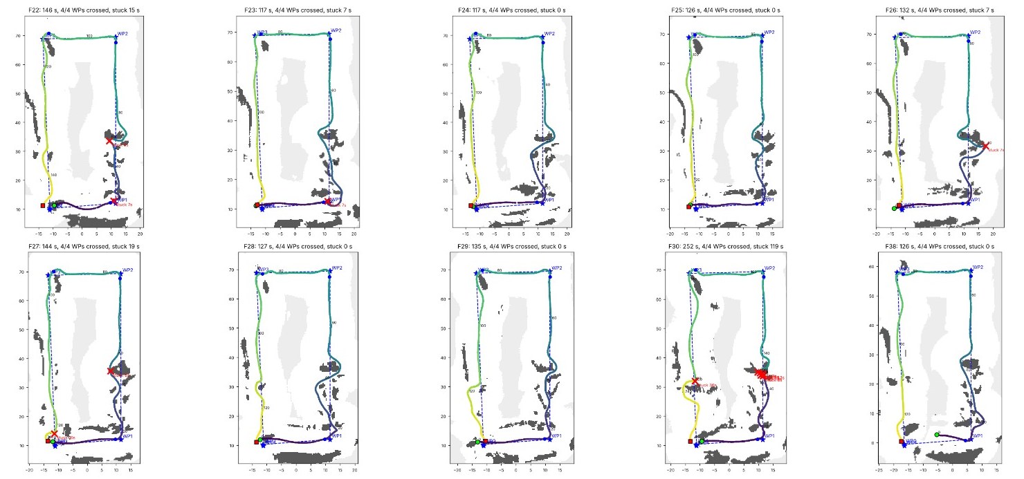
What we would want you to know first. On one of the ten laps the robot spent two minutes held up: with its nose under the side of a parked pickup, which sits above the ground the map tracks, and on a mound in open grass that tilted it 15 degrees. A thin tent guy-line held it once on another run. Each is now a known case, and the logs that show them are the logs the next release is trained on.
On its own robot today. On your vehicle next.
The robot: TerraScout.
The vehicle in every film above. 20 to 40 kg, one-soldier lift, four hours and twenty miles on a charge, a payload rail. It exists now, so a unit can field it in numbers and learn what it does on its own ground. A teleoperated robot of this class costs $55,000 to $117,000 and needs a soldier per robot; TerraScout with the stack on it is priced inside that band, and the soldier is free.
The kit: the same brain on the vehicle you already have.
One sealed module and a harness on any drive-by-wire chassis: the side-by-side, the tracked carrier, the robot a program already builds. Commercial cameras, a consumer-grade inertial unit, one embedded computer. The sensors it replaces, a multi-plane lidar and a tactical-grade inertial unit, cost more than the whole kit. One model, one release process, so every vehicle that drives improves all of them.
Prices for teleoperated robots from public program records for fielded small robots of this class; sensor prices from published list prices. EarthSense prices under NDA.
Already in production, on ground nobody rehearsed
A demonstration proves a stack can drive a course once. A unit needs it to drive ground nobody rehearsed. That takes vehicles, hours and bad ground, accumulated by paying customers for eight seasons on two continents. The defense runs above are recent; the record under them is not.
The alternatives, by class
| Class | Soldiers per vehicle | Needs GPS to move | Needs a prior map | Emits | Learns from the fleet | In production off-road |
|---|---|---|---|---|---|---|
| A soldier driving, or walking | One, exposed | No | No | Whatever the soldier carries | No | Yes |
| Teleoperated small UGV | One, full time, in link range | No | No | Radio, continuously | No | Yes |
| GPS-waypoint kit | One planner per mission; stops without a fix | Yes | Route planned in advance | Radio for re-planning | No | Yes, open ground |
| Full-stack autonomy for high-value vehicles | One supervisor to several | Usually, for localization | Usually, dense | Lidar and radar, continuously | Vendor retrains on its schedule | Yes, on those vehicles |
| Compact sensor-fusion and camera kits | One supervisor to several | Varies | Varies | Lidar where fitted | Vendor-labeled | Demonstrations |
| Terra AI kit | One supervisor to several; none required to move | No; used when present | No; builds its own MCOO | Nothing in the kit | Yes; every vehicle labels its own data by what it drove | Eight seasons, two continents |
By class, from public descriptions. A company-by-company comparison is available under NDA.
Why a buyer can own it, and why it keeps getting better
You own it.
FeaturePerception, estimation, planning and control written in-house. Five granted US patents, four pending, all assigned to EarthSense. No per-unit royalty.
BenefitRoadmap, data rights and price are yours.
It learns from the ground, not from a labeler.
FeatureTraction experienced becomes the label; the corpus encodes how a surface took load, not a human's opinion of what it is.
AdvantageGeometry cannot tell traversable snow from a snowbank or tall grass from a wall; a labeled dataset is only as big as the labeling budget.
BenefitIt transfers between theaters, and cheap vehicles teach it from operations.
Sensor agnostic, camera sufficient.
FeatureCameras and inertial are sufficient; thermal, lidar and radar are input channels the perception layer consumes unchanged. The vehicle profile is separate from the model. Because the model classifies what it sees, it tells dust and smoke from obstacles, which a point cloud cannot.
BenefitOne brain from a one-metre robot to a full-size vehicle at 30 km/h, without retraining per vehicle.
One learned layer inside inspectable code, covert by design.
FeatureA single bounded learned component, traversability, inside deterministic planning and control; all inference onboard; no radio, no cloud dependency in the kit.
AdvantageEnd-to-end learned driving cannot be argued to a safety board; a networked stack is an attack surface.
BenefitThe safety case is argued once, the model keeps improving underneath it, and there is nothing in the kit to spoof.
One sealed module and a harness
| Forward stereo | GMSL2, IP66, integrated inertial; second source qualified |
| Rear and flank | Three mono GMSL2 cameras, US-sourced |
| Overhead | One GMSL2 hemispherical fisheye |
| Night | Uncooled thermal camera, optional; demonstrated November 2026 |
| Inertial | Consumer-grade MEMS; the stack does not lean on it |
| GNSS | Commercial receiver, used opportunistically; no keyed receiver, no crypto to recover |
| Compute | NVIDIA Jetson Orin NX 16GB, carrier, NVMe; all processing onboard |
| Power and enclosure | Sealed, vehicle 12/24 V; no actuation, no display, no radio |
One model and one release process, from a one-metre scout to a full-size vehicle at 30 km/h. No actuation in the kit, no vehicle redesign.
Twenty years of work, by the people who still field it
Two decades on autonomy for vehicles that must keep operating outside the envelope they were designed for: first adaptive flight control, then the ground, where a farm gave the problem its hardest form. Built by a professor of robotics, the PhDs he trained, and the engineers who turned it into a product fielded on 160 robots. Origins in an AFOSR Young Investigator award and Army Research Laboratory support (Cooperative Agreement W911NF-20-2-0184). A US company with no foreign ownership. The people who filed the patents still field the systems.
The Jeep of autonomy. The 1941 Willys Jeep was not the Army's most capable vehicle. It was the one the Army ran on: it worked, it was affordable, it got the job done, and it could be issued everywhere and fixed with a wrench. Terra AI is that layer for autonomy: the same on every vehicle, priced to be issued in numbers, deployable now, fixed by the unit on its own ground. The Army made this move once already, in the air, when a few dollars of MEMS sensing and a GPS chip replaced a fiber-optic gyro costing tens of thousands. Ground autonomy is at the same point.
Put it on your ground
In four weeks: driven on a course it had never seen, driven at night on a thermal camera, run on Army ground at Detroit Arsenal. EarthSense is in conversations with several platform makers and primes about how this reaches the field; the company comparison, the prices and the operating plan are available under NDA.
It comes on its own robot today and as a kit for the vehicle you already build. The fastest way to judge it is to put it on your ground. We will bring the team and the robot.